
With the Atal Setu reducing travel time between Mumbai and Pune, there are predictions about a Mumbai-Pune megapolis, a vast city straddling the Western Ghats. Nadir Godrej, Managing Director of Godrej Industries, said that he visualised a vast urban area like Boswash in America, a contiguous conglomeration of cities stretching from Boston to Washington, enveloping other big cities like New York. Other industrialists have voiced similar opinions.
However, scientists have said that a megapolis will be a disaster for the Western Ghats, the hilly and forested region dividing the cities. The Western Ghats has been identified as one of the 36 global biodiversity spots containing a high percentage of endemic life forms, with its forests and hills having a significant influence on the rainfall and weather in the region.
Dr T V Ra Ramachandra |
Free Press Journal spoke to Dr T V Ramachandra who is part of an ongoing research by the Western Ghats Spatial Decision Support System (WGSDSS) project of the Energy and Wetlands Research Group, Indian Institute of Science (IISc), Bengaluru.
The study: aims & findings
The study aims to enhance governance transparency while meeting societal needs, and the prudent management of the ecologically and hydrologically vital Sahyadri range, the local name for the Western Ghats. The WGSDSS study analyses ecologically sensitive regions using temporal remote sensing data.
The study found that with the increasing urbanisation of the hills, forests are getting fragmented, damaging the ecological diversity and threatening the water security of people living in the peninsular region who depend on water from rivers flowing east from the Western Ghats.
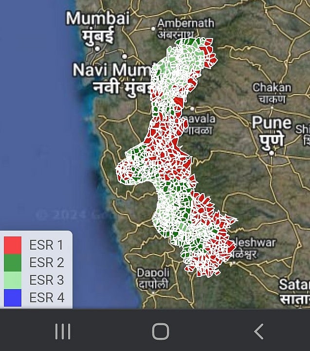
Red areas shows ESR 1 areas in Pune district. Pune city in blue. |
Excerpts from the interview:
Question. What do think about the idea of a Mumbai-Pune megapolis straddling the Western Ghats?
Answer. It is going to be a disaster. Western Ghats give water, which in turn gives food security. The Western Ghats has sequestered, or absorbed, 1.2 MGg (million gigagrams) of carbon from the air and adds 33,000 to 40,000 Gg (equivalent to 37.5 million tonnes) to its biomass every year, equivalent to the carbon emitted by a large city. (Mumbai, for instance, released 23.42 million tonnes of carbon in 2019). Construction and deforestation have created disasters like the landslide near Karjat in 2023 that killed more than 100 people. The megapolis plan is an illogical project. A megapolis will be a disaster. Apart from other problems, there will also be more human-animal conflicts.
Question. Your study has shown a 5% decline in the area covered by evergreen forests in the Western Ghats. What are the consequences of this change?
Answer. This decline was between 1985 and 2019. Our prediction shows further degradation by 2030. There has been an increase in temperatures, a rise in vector-borne diseases like malaria. There is a change in rainfall patterns in the areas near the Western Ghats. With further degradation, the number of rainy days will change. The rain which fell over a four to six-month period will fall in a few weeks. Our study on annual rainfall in the Sharavati River basin (in the Karnataka stretch of the Western Ghats) has shown that rainfall in the degraded areas in the basin has fallen to 1700-1900 millimeters while the forested areas in the same basins get the old average of 3000-3500 millimeters. This difference is clearly due to the degradation of forests, and not due to a rain-shadow effect (Where mountains block rain in the leeward side of monsoon currents).
Question. The area between Mumbai and Pune is already seeing a lot of construction, with land being diverted from forests to roads, housing, industry, and recreational developments.
Answer. When you talk of a megapolis, land use will change drastically. Industry and towns will come up. There has been an increase of 4.5% in built-up areas in the hills. We need to be cautious about these plans. We need a cluster-based approach.
Question. The Maharashtra section of the Western Ghats are among the least protected areas of the mountain range. What will be the consequences of unbridled development in the Mumbai-Pune corridor?
Answer. Between 40 and 45% of the Western Ghats in the Maharashtra section of the Western Ghats are degraded. Animals from the degraded areas are migrating to forests in neighbouring states, increasing human-animal conflicts. We have not accounted for the cost of land degradation in our Gross Domestic Product (GDP). We are not looking at this cost to GDP. We are only looking at the benefits.
Question. What will be the impact of such urbanisation on people in the Western Ghats who depend on traditional occupations like farming?
Answer. Our study found that people living in degraded land in the Western Ghats had income levels that were just a quarter of the earnings of those who lived in areas where the ecosystems were not impacted by development. This was mainly due to a lack of water and lower yields in farms because of the decline in pollination activity by bees.
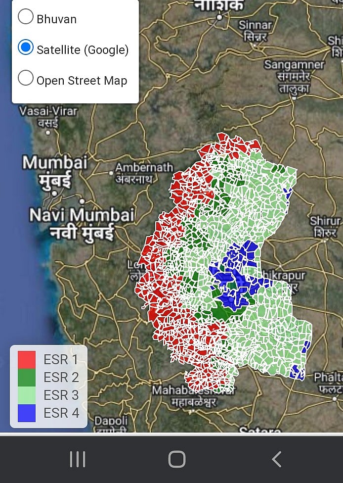
ESR 1 areas in Raigad district between Mumbai and Pune |
Question. People living in the Mumbai and Pune urban regions need the Western Ghats as recreational space. There is a mushrooming of resorts and recreational areas in the hills. How can we ensure that the hills do not bear further damage because of this demand?
Answer. There is mushrooming of resorts in valley areas. Instead of tourists in these resorts, we should encourage guests in every house. The tourism policy should be implemented at the grassroots level. Empowerment the local people. Think of a holistic plan; the GDP will go up. Government can avail carbon credits by protecting the ecology.

A grid-wise analysis of the Western Ghats shows that 32% of the area under ESR-1 (ecologically sensitive region) denoting very high ecological fragility, 16% (373) grids under ESR-2, which has potential to be ESR-1, 34% (789) and 18% (412) under ESR-3, and 4 respectively, with moderate and least ecological fragility. ESR analysis depicts 63,148 km2 area under very higher ecological fragility, 27,646 km2 under high ecological fragility, 48,490 km2 as moderate and 20,716 km2 as low fragility.
IISc said that the comprehensive knowledge of the ecological fragility of a region is essential for evolving strategies for conserving the area, which entails identifying factors responsible for ecological sensitiveness, including landscape dynamics, and visualising future transitions to mitigate the problems of haphazard and uncontrolled development approaches.