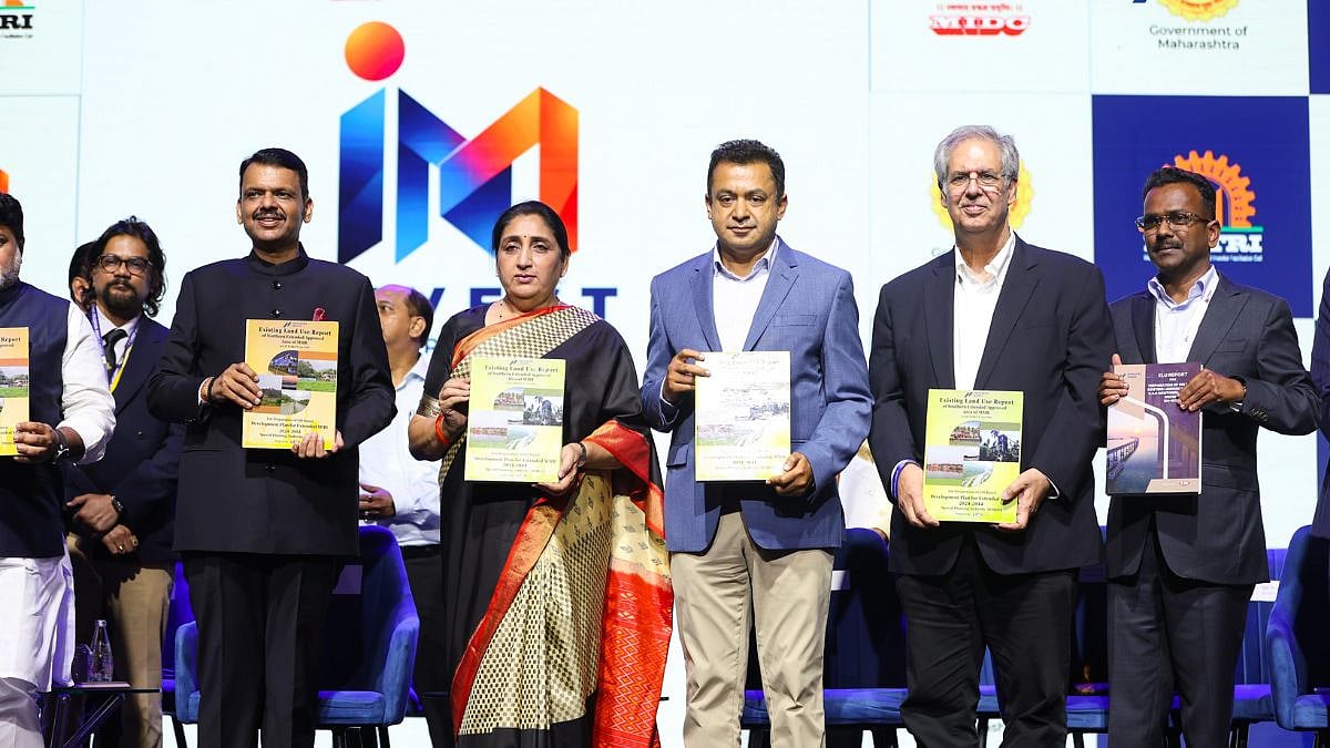
Mumbai, October 3, 2026: The Mumbai Metropolitan Region Development Authority (MMRDA) has completed three Existing Land Use (ELU) reports for areas under Mumbai 3.0 and Mumbai 4.0, covering nearly 2,008 sq km across 565 villages, in a record two-and-a-half months.
The exercise is expected to provide the spatial foundation for future master planning, infrastructure development, employment generation, housing and environmental management across the expanding Mumbai Metropolitan Region (MMR).
The three reports cover KSC New Town, Northern Extended Notified Area (ENA) in Palghar and Southern ENA in Raigad, including Alibag. The reports provide a detailed database of existing settlements, infrastructure, terrain, natural resources and prevailing land-use patterns.
MMRDA Metropolitan Commissioner Dr Sanjay Mukherjee handed over the reports to Chief Minister Devendra Fadnavis during the Invest Maharashtra launch.
Advanced Technology Used For Mapping
The ELU exercise has used advanced geospatial technologies, including aerial LiDAR, high-resolution imagery, DGPS ground control and GIS mapping, along with cadastral records and field verification.
For KSC New Town, the report covers around 324 sq km and 124 villages across Pen, Uran and Panvel talukas. MMRDA is the New Town Development Authority for the area, which is witnessing rapid transformation due to projects such as Navi Mumbai International Airport, JNPA, Atal Setu and the proposed Virar-Alibaug Multi-Modal Corridor.
The database is expected to support master planning for urban, logistics, commercial and industrial growth while taking into account agricultural land and environmental resources.
Palghar And Raigad Areas Covered
The Palghar ELU report, covering around 1,007 sq km and 224 villages, captures an area characterised by forests, rivers, agricultural land, a 40-km coastline, mangroves, wetlands and tribal settlements. The region is also emerging as an industrial, logistics and tourism corridor, supported by MIDC Tarapur and road, rail and coastal connectivity.
The Southern ENA report, covering around 677 sq km and 217 villages, includes the Alibag region. The area’s beaches, forts and natural landscapes give it a strong tourism and ecological character, while MIDC areas and transport corridors are driving industrial and connectivity-led growth.
Digital Twins To Guide Planning
MMRDA plans to use the ELU database as a base for creating digital twins and scenario models. These tools will allow planners to assess the potential impact of different development patterns on transport, infrastructure demand, flood risks, environmental systems and access to public services before major investments are undertaken.
The authority said the database would also enable land-use and mobility planning to be undertaken together, helping identify locations for growth centres where housing, workplaces, education, healthcare and recreational facilities can be better connected.
Future planning proposals are expected to identify locations for commercial districts, offices, industrial and logistics hubs, markets, e-commerce facilities and emerging digital infrastructure such as data centres and AI factories.
Housing And Employment Planning
MMRDA said improved connectivity and phased infrastructure could help attract investments and create opportunities for jobs, businesses and skills development. The planning exercise will also seek to identify serviced residential land and locations for affordable housing closer to employment centres and public transport.
Compact and mixed-use growth centres are proposed to be planned alongside schools, universities, hospitals, community facilities and public spaces. Tourism, heritage and local livelihoods will also form part of the planning considerations.
Focus On Green And Blue Infrastructure
The authority said around 45% of the combined study area falls under forest and green-area categories. MMRDA plans to work with relevant authorities on protecting and restoring natural assets, including mangroves, wetlands, rivers, water bodies and natural drainage systems.
The ELU database will help identify areas suitable for development as well as locations requiring conservation or restrictions through detailed statutory planning and environmental assessments.
The proposed planning approach also envisages parks, shaded streets, recreation areas and interconnected green networks, alongside protected waterways and water bodies. Infrastructure planning will incorporate green and blue infrastructure, with emphasis on public transport, renewable energy, water-sensitive design and resource efficiency.
MMRDA said the ELU findings will now be translated into planning proposals and phased infrastructure investments under its broader vision of “Mumbai in Minutes”, “Rebooting Mumbai” and “Reshaping MMR”.
Leaders On Regional Planning
Chief Minister Devendra Fadnavis said, “The completion of these ELU reports gives us a stronger foundation for planning Mumbai 3.0 and Mumbai 4.0. By bringing transport, employment, housing and environmental protection into one coordinated planning approach, we can spread opportunity across the metropolitan region. Our aim is to attract investment, create jobs and improve quality of life as MMR drives Maharashtra’s progress towards a USD 1 trillion economy.”
Deputy Chief Minister and Chairman, MMRDA, Eknath Shinde said, “Our priority is to ensure that infrastructure opens up opportunities for citizens across the region. These reports will help us plan connected growth centres with homes, employment, schools, healthcare and public spaces. A coordinated approach to land use and mobility can support affordable living while protecting the natural systems on which the region depends.”
Deputy Chief Minister Sunetra Ajit Pawar said, “Planned development must improve everyday life for families and communities. The ELU database will help guide investment in housing, education, healthcare and essential services, while respecting local livelihoods and environmental needs. It provides an opportunity to make the next phase of metropolitan growth more inclusive, accessible and sustainable.”
Dr Sanjay Mukherjee, Metropolitan Commissioner, MMRDA, said, “We intend to turn this spatial database into a practical tool for shaping the region’s future. It will support digital twins, proposed land use and modelling of transport, infrastructure and development choices. Our goal is to create compact, connected centres where people can live closer to work, learning, healthcare and recreation, with greater access to open spaces and stronger climate resilience. This is the foundation for a more liveable MMR.”
Connectivity Boost
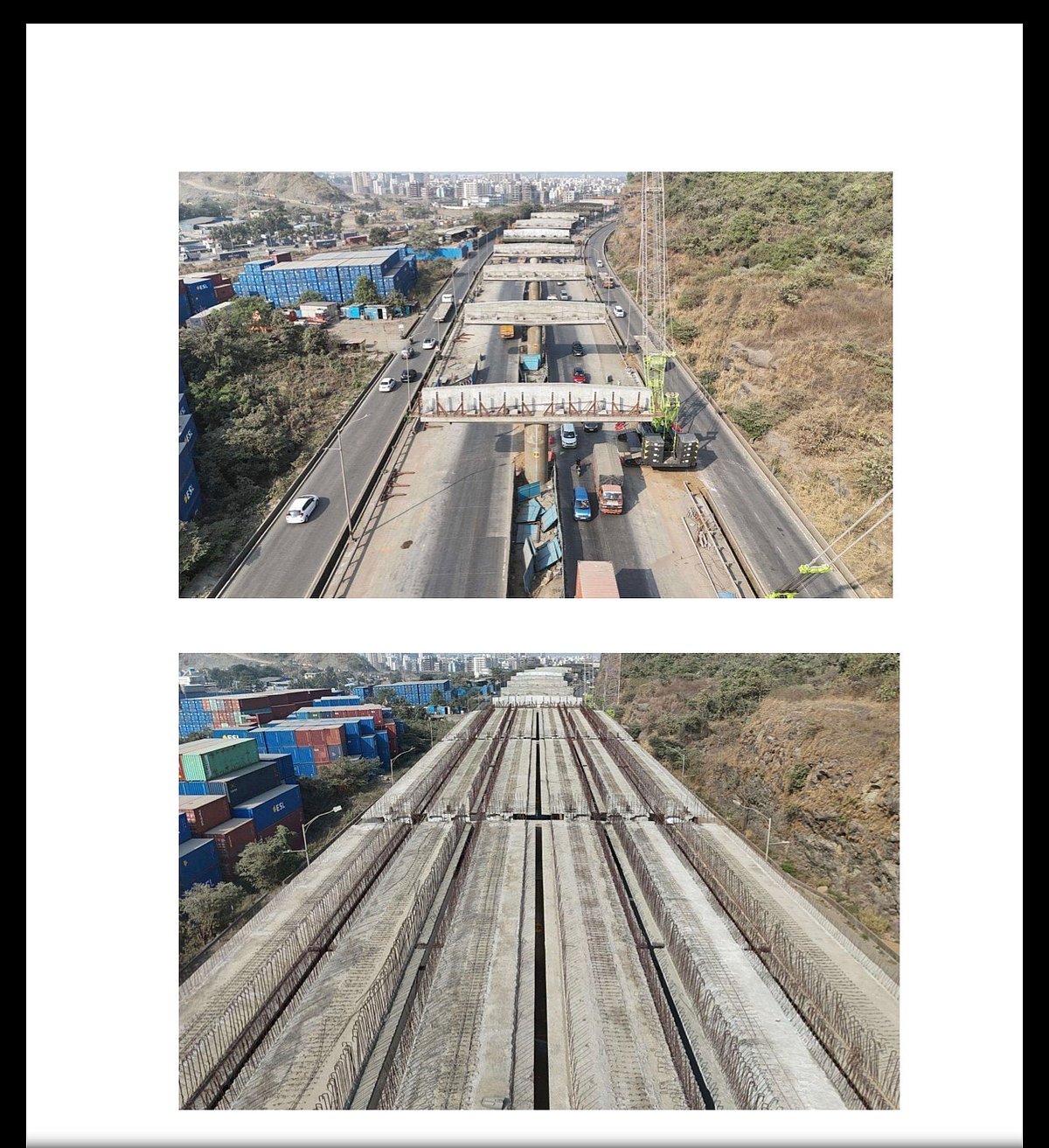
Mumbai–Pune Expressway–Atal Setu Connector taking shape
7.35-km elevated corridor connecting the Mumbai–Pune Expressway with the MTHL/Atal Setu interchange at Chirle
Signal Free Travel
Six-lane corridor
Completion deadline: February 2027
Chirle Section
98% pier casting completed
Pier caps: 85% completed
T-Girder casting: 100% completed
Composite Girder fabrication: 100% completed
PT-Girder erection: 77% completed
I-Girder erection: around 71% completed
Deck slab: 42% of spans completed
RE wall: 73% completed
Palaspe Section
Pile-group foundation 54% complete; pile-cap work 24%; pier casting 19%
Service-road work at Palaspe:
Earthwork and sub-base progress at around 11%
Key Role
• To serve as an important dispersal link for Atal Setu traffic
• Time Savings: Cuts travel time between South Mumbai and Pune by 60 to 90 minutes.
• No Signals: Removes the need to navigate local Navi Mumbai roads and Panvel traffic bottlenecks.
• Airport Access: Provides direct connectivity to the upcoming Navi Mumbai International Airport.
• Freight Boost: Improves container and cargo movement from the JNPT (Nhava Sheva) port directly onto the expressway network.
Connectivity Benefits
Expected to strengthen the road link between Mumbai, Navi Mumbai and the Mumbai–Pune Expressway
This connector will enable Mumbaikars to access the Mumbai–Pune Expressway without any signal interruptions, creating a faster and more seamless travel corridor through Atal Setu.
Also Watch:
Benefit those commuting between Mumbai and Pune—making it easier to live in one city and work or study in the other.
The connector aims to achieve—bringing regions closer and making everyday journeys simpler, quicker, and more efficient.
Airport Link
Palaspe and Chirle sections will improve connectivity with the proposed Navi Mumbai International Airport.
To get details on exclusive and budget-friendly property deals in Mumbai & surrounding regions, do visit: https://budgetproperties.in/

