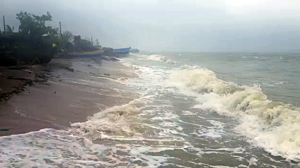
Mumbai, May 12: India’s west coast is likely to witness its first cyclonic storm of the year by May 16, with the India Meteorological Department (IMD) predicting its ‘likely formation’ over the East Central Arabian sea on Tuesday and Wednesday. The IMD has also issued heavy rainfall alerts for Maharashtra and Goa coast, along with the Lakshadweep area from May 13 to May 15, in addition to issuing warnings about a tidal wave and high-speed winds.
According to the forecast issued on Wednesday, a low-pressure area is expected to form over the Arabian Sea and Lakshadweep. IMD Mumbai officials said that this was likely to intensify into a cyclonic storm around May 16. Once formed, it would lead to a cyclonic storm named Cyclone ‘Tauktae’ (meaning highly vocal gecko) by Myanmar.
The IMD said a low-pressure area was very likely to form over the southeast Arabian sea around May 14. Fishermen along and off the Maharashtra coast have been advised not to venture into the sea from May 15. The IMD has issued a yellow alert, forecasting a thunderstorm with lightning, heavy rain and gusty winds at isolated places in Ratnagiri, Sindhudurg, Ahmednagar, Kolhapur, Pune, Satara, Sangli, Solapur, Beed, Nanded, Latur, and Osmanabad for May 14 and 15.
“A low-pressure area is very likely to form over Southeast Arabian Sea around May 14 morning. It is very likely to move north-northwestwards across the Southeast Arabian Sea and adjoining the Lakshadweep area and intensify gradually. It may intensify into a cyclonic storm over the east-central Arabian Sea around May 16 and continue to move north-northwestwards. Under the influence of the weather system, several districts near Maharashtra and Goa coast will witness heavy rainfall activity accompanied with gusty winds,” said Shubhangi Bhute, Scientist, IMD Mumbai.


According to Vagaries of the Weather, a popular private weather blog and a group of weather enthusiasts, “Region of convection over Central Arabian Sea is developing and shifting Eastwards. Vortex currently shows vertical wind shear in the region, but low VWS in the South- East of the region. Hence, a Well marked Low will form off the Kerala Coast around the 14th.”
It further predicted the formation of Cyclone Tauktae in a favourable environment by May 16 and May 17, on the North Karnataka/Goa coast.
“Cyclone will then track North/North-West towards the Coastal Sindh region. Very Heavy rains and gusty winds in Kerala on May 14 and May 15 and in Coastal Karnataka on May 16 and May 17 along with gusty winds. Goa coast will witness very heavy rains, maybe 100 mm rain with very gusty winds, 50-60 kmph on May 16 and May 17. In South Konkan, where the Cyclone will graze by, may not have a direct hit, but heavy rains and windy conditions (winds around 35-45 kmph) from May 15 to May 17 and will subside by May 18.
“Whereas in North Konkan, region Mumbai, will most likely not get directly affected, but cyclonic condition like gusty winds of 30-40 kmph. with moderate rainfall will be witnessed on May 16 and May 17.
"Pune will witness light to moderate rains on May 15 and May 16, but with strong gusty winds. The storm is likely to turn track towards Surat and Bharuch and the areas will get moderate showers on May 16 and May 17, with gusty winds,” according to the Vagaries of the Weather blog.
Meanwhile, the private weather forecast agency, Skymet Weather said: “No storm has formed during the last 10 years in May over the Arabian Sea which tracked closer to the coast. Cyclone ‘Phet’ was the last storm in May 2010 (May 30 - June 07) that travelled over the deep ocean and finally came sufficiently close to Sindh and Kutch region. Ultimately it fizzled out over the sea itself. However, the Bay of Bengal has a record of hosting cyclones in May which threatened the Indian coastline. Cyclone Viyaru in 2013 and more closely Cyclone Roanu came dangerously close all along the East Coast but finally struck Bangladesh.”
According to Skymet, the cyclonic storm formation at this point of time is consequential for the advance of the monsoon stream over the Indian waters. “Irrespective of its track, the storm will clear from our area of interest latest by 21st May. Still, sufficient time to recover and re-establish the normal pattern to welcome the southwest monsoon without inordinate delay,” the agency said.