Bhopal (Madhya Pradesh): The proposed Bhopal Development Plan 2047 envisages a 51-km Growth Corridor from Narmadapuram Road to Indore Road as a major zone for future residential, commercial and metropolitan development.
But within a few hours of its official release, the plan came amid an ongoing debate over commercial activities in residential areas.
Residents have raised concerns that provisions allowing certain land-use changes through fees could increase commercialisation of residential neighbourhoods.
The draft provides for a 75-metre-wide main road, with high-density mixed-use development up to 300 metres on either side, creating a development belt of nearly 675 metres.
The draft also envisages golf-course development at the Bhanpur Khanti site, new sports and cultural areas, protection of water bodies and preservation of forest and ecological zones.
1.0 additional FAR free, MRTS and service roads
According to the draft, residential, commercial, public and semi-public activities can be combined or developed separately within the Growth Corridor. Projects along the 75-metre road will require a minimum 4,000 sq m plot, while internal roads must be at least 12 metres wide.
The proposal provides 1.0 additional FAR free of cost over the prescribed FAR. The main corridor will also include provisions for MRTS, service roads and plantation, with radial roads connecting the corridor to other parts of the city.
Existing bypass to become growth corridor
The draft proposes a new outer Bhopal-Bhauri bypass within the next 10 years for diverting heavy traffic. After this, the existing bypass is envisaged as a major urban route and Growth Corridor.
A separate 60-metre-wide greenfield bypass is proposed along the outer boundary of the investment area. It will have 50-metre green zones on both sides, along with service roads.
Residents raise concerns over fees
Residents, including Purnendu Shukla, have alleged that provisions for occupancy conversion, parking, regularisation, premium FAR, additional FAR, land-use change and infrastructure charges could enable greater commercial activity in residential areas through payment of prescribed fees.
They have cited an example of a claimed Rs 31 lakh occupancy-conversion charge for a 4,500-sq-ft plot near Arera Colony's 10 Number Market, along with an alleged additional Rs 20 lakh charge in cases involving earlier unauthorised conversion.
These figures are residents' claims and would require verification from the competent authority.
Three-phase development till 2047
The city's development is proposed in three phases: Phase I till 2033, Phase II from 2033 to 2040 and Phase III till 2047.
The plan also proposes creating a digital twin of Bhopal within three years of implementation, covering land use, buildings, transport, drainage, water supply, green areas and population data.
TDR and 31 zoning areas
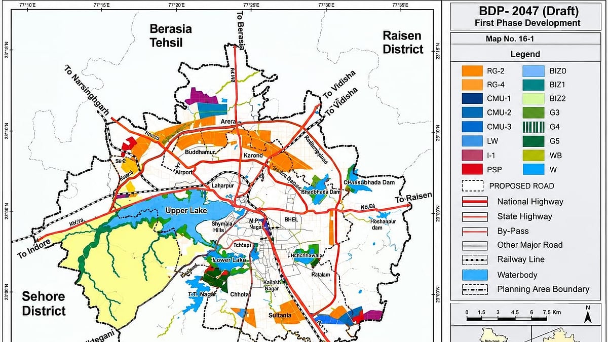
The draft opens the way for Transferable Development Rights (TDR) when private properties are affected by road widening. It also proposes zoning across 31 areas, including residential, commercial, industrial, transport, recreational, ecological and water-body zones.
The TOD zone covers 500 metres on either side of Metro corridors, while CMU zones cover existing and proposed commercial areas. Industrial zones are divided according to the nature and pollution potential of industries.
Key zones under the draft
Zone - Proposed purpose
RG-1/RG-2 - General residential areas
RG-3 - Protected established residential areas
RG-4 - New residential development
RG-5 - Dense old-city areas
GC - 51-km Growth Corridor
TOD - Metro-oriented development
OC - Old City and heritage areas
CMU-1/2/3 - Existing and new commercial areas
I-1/I-2 - Industrial areas
PSP - Administrative, educational, health and social institutions
G-1 to G-5 - Gardens, sports, forests and green areas
W/BIZ-0/1/2 - Water bodies, FTL, buffer and surrounding areas
T - Transport infrastructure
V/VE - Rural settlements and notified rural population