Cruising down the Moran Emergency Landing Facility (ELF) in Assam last November felt less like a drive and more like a rehearsal for flight. The sheer, imposing scale of the stretch—vast, grey and seemingly infinite—commands a certain silence. It is a disorienting sensation. Your hands grip a steering wheel, yet your eyes insist you are at the helm of a cockpit. There is a rare, cinematic quality to traversing a surface engineered for the crushing weight of a fighter jet rather than the rhythmic hum of highway traffic.
However, the thrill of testing such flawless tarmac comes with a modern caveat. The urge to push the needle is met swiftly by hidden speed cameras that click before you can blink, serving up a hefty fine on a platter to remind you that this runway still follows the rules of the road.
With Prime Minister Narendra Modi set to dedicate this marvel to the nation on February 14, the air in Assam is thick with anticipation. The mood is undeniably buoyant, charged with the electric energy of a state on the cusp of an inauguration and an impending Assembly election.
A strategic truth
Yet, beneath the political fanfare and the promise of "thunderous landings" by Sukhois and Rafales, lies a sober, strategic reality. This isn’t just a road. It’s a shield. As the shadow of tension lingers across the Line of Actual Control (LAC), this stretch serves as a critical pivot for national security.
Nestled in the Dibrugarh district, it provides a vital tactical reserve for nearby airbases like Chabua and Jorhat, ensuring that the Indian Air Force remains unyielding even if primary airfields are hindered by inclement weather or the fog of conflict. Chabua is one of the two Sukhoi-bases in Northeast India, the other being Tezpur.
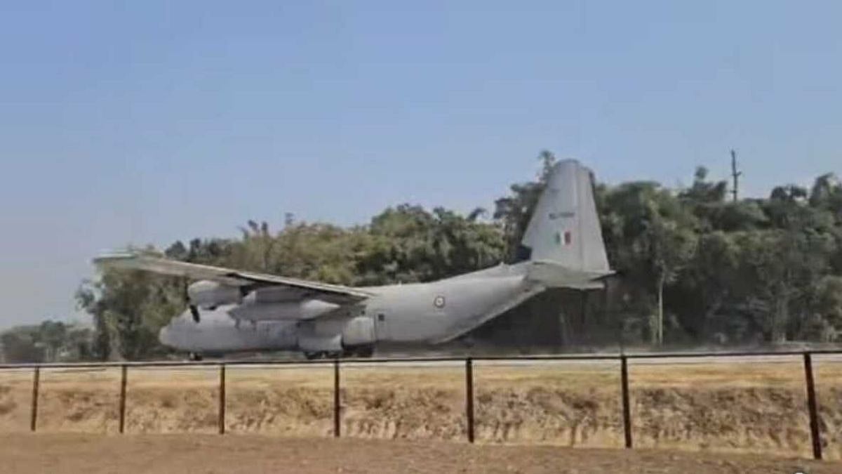
As the first facility of its kind in the Northeast, this ELF, 4.2-kilometre stretch of National Highway 127, marks a significant milestone in regional infrastructure. It transforms a precise corridor of highway into a versatile alternative runway, capable of handling the intense demands of fighter jets, heavy transport aircraft and helicopters alike.
Beyond its martial strength, the facility is a lifeline—an instrumental hub for Humanitarian Assistance and Disaster Relief (HADR) operations, ensuring help can reach the most far-flung corners of the region when it is needed most.
The engineering of the Moran airstrip transcends standard roadwork, utilising high-grade reinforced concrete specifically formulated to endure the punishing impact of heavy aircraft and the searing heat of jet blasts. The thickness of this tarmac is roughly double that of a standard national highway to withstand the "pavement classification number" required for a fully loaded Rafale or C-130J.
By intentionally omitting a central median, the design creates an expansive, unobstructed corridor that can accommodate wide-wing military assets.
This specialised construction ensures the facility can handle the high-speed demands of advanced fighter jets like the Su-30MKI and Rafale, alongside the immense weight of heavy-lift transport aircraft such as the C-130J Super Hercules.
China infra boost makes Moran ELF essential
As Damien Symon, a geo-intelligence expert with The Intel Lab, puts it: "A 3.6 km stretch of highway near the India-China border is being commissioned this week as an Indian Air Force runway for emergency fighter operations... located 240-km from the LAC in Assam, this airstrip enhances dispersed and survivable air power in crisis scenarios."
Although Symon differs on the length of the ELF what is striking is the distance from the LAC which is less than 250 kilometres.
In the high-altitude expanse of the People’s Liberation Army (PLA) Western Theatre Command, overseeing the Tibet and Xinjiang regions bordering India, China has implemented a sophisticated "dual-use" infrastructure strategy. While Beijing avoids the public labelling seen in India’s ELSs, the reality reveals a deep integration of combat readiness into the very asphalt of the frontier.
As of early 2026, the scale of this transformation is immense, with China completing or upgrading approximately 37 airports and heliports across the theatre since 2017. A critical mass of these facilities is strategically positioned within a 50 to 60-kilometre radius of the LAC.
Key arteries like the G219 and G318 highways have been widened and hardened at specific stretches to facilitate the rapid dispersal and landing of advanced fighter jets, such as the J-11 and J-16, during active contingencies.
The PLA has essentially woven emergency landing capabilities into the region’s primary arteries to ensure that air operations remain resilient even if major hubs like Lhasa Gonggar or Hotan are targeted. The G219 highway, acting as a strategic life-line parallel to Ladakh and Arunachal Pradesh, is now engineered for mobile logistics and aircraft staging.
Perhaps the most potent symbol of this forward-leaning posture is the Lhunze airbase in Tibet, located a mere 40 kilometres north of the McMahon Line. The facility has been fortified with 36 hardened aircraft shelters, new administrative blocks and expanded aprons. Lhunze allows China to forward-deploy fighter aircraft and drone systems at the very edge of the frontier.
The architecture of deterrence
India has identified nearly 30 such strategic corridors, weaving a nationwide web of aerial resilience. The journey began with the Yamuna Expressway in 2015, but by 2026, the stakes have evolved. From the high-altitude assets on the NH-44 in Jammu & Kashmir to the Ganga Expressway—which recently proved its worth with successful night-landing drills in 2025—India is no longer just building roads, it is building a distributed air force.
The Moran ELF is the latest, and arguably most critical, piece of this puzzle. It represents a shift in doctrine—one that acknowledges that in modern conflict, fixed airbases are targets, but a highway is an elusive, ever-shifting sanctuary.
