The facts are scattered around us. Join them as you would join dots on a paper, and a pattern emerges about Mumbai’s development. It points to a disquieting evaluation which, then, raises critical questions about the future of the city, once Urbs Prima in Indis, as the Latin phrase went.
Coastal road expansion and ecological cost
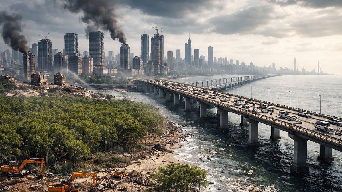
First, the coastal road project now stretches from South Mumbai right up to Bhayandar, with the Versova-Bhayandar stretch intensely opposed by environmental groups, especially the Save Mumbai Mangroves, considering that nearly two-thirds of the 60,000 mangroves over 103 hectares will be legally cut down or displaced. Despite the pushback by activists and planners, who have suggested alternative alignments, the Brihanmumbai Municipal Corporation (BMC) and the state government, with the approval of the Bombay High Court as well as the Supreme Court, are at it. Note here that not only are alternative alignments possible, but specific suggestions have been made to the BMC to preserve the ecology.
Second, the coastal road is, as per plans, set to be extended all the way up to Palghar. The Bhayandar-Palghar stretch will be a 55-km high-speed sea link. The engineering cost of this arm of the coastal road is unclear; the environmental cost is literally up in the air. MMRDA has positioned this as the grand design of coastal connectivity. ‘At what cost?’ is a question that begs an answer. Its proposal for the Uttan (Bhayandar)-Virar section received approval on March 11. Forget the provisions of the Coastal Regulation Zone law; the approval said a “dense green belt of Miyawaki forest will be developed at the intersections on the completion of construction”.
Massive public expenditure on road infrastructure
Given that the 26 km of the Versova-Bhayandar road is estimated conservatively to cost Rs 22,000 crore, which makes it roughly Rs 846 crore per km, the next stretch of 55 km up to Palghar would send us a bill of not less than Rs 47,000 crore or thereabouts. Add to this all the expenditure made on the coastal road so far. It’s a grand total of at least Rs 91,500 crore. That is public money being spent on a road that is intended to benefit largely private car users who make about 10 per cent of all Mumbai’s modal transport share.
Trans-harbour link and shift from rail to road
Third, the 22-km trans-harbour link, or Atal Setu, has been put in place at a cost of nearly Rs 17,800 crore, mainly for private car users, making travel easier between the southern side of Mumbai and Navi Mumbai, including the new international airport. It is interesting to watch people’s reactions turn from amazement to resignation when the old plans of the trans-harbour link are explained; it was meant to be a rail link, then altered to include a road, till the railway line was quietly erased, like Mumbai’s BEST bus services have been.
Ecological degradation and policy choices
Fourth, by design and policy, Mumbai is being stripped of its ecological cover and natural wealth, from its wetlands to its forest cover, even as the BMC shows off its Climate Action Plan. Salt pan lands across 103 hectares have been approved for construction to rehabilitate those displaced by the Dharavi redevelopment project. Why can’t all of them, like other slum redevelopment projects so far, be rehabilitated in situ is a question few officials will even hear, let alone cogently answer.
The threat to the Sanjay Gandhi National Park just intensified. The draft zonal plan for two of its three eco-sensitive zones—to construct commercial complexes and tourism facilities—was approved last week, again, despite the tonnes of objections and suggestions by environmentalists, social activists, tribal communities that resist displacement, and planners-architects. The BMC keeps pointing to the illegal or unauthorised construction on about 33-34 per cent of nearly 60 sq. km of the eco-sensitive zones. The question that arises is simple: why open up the remaining area for construction instead of demolishing this, save the old tribal hamlets? Then, between 2016 and 2021, more than 2,000 hectares of tree cover was cut down; there is no comparable data for the next five.
Climate risks and scientific warnings
Five, scientific studies and reports have told us of sea level rise of less than a metre increasing the intensity of flash floods and affecting 2-3 million people within a kilometre of Mumbai’s coastline; of possible submergence of several parts of the island city that could add up to about 28 sq. km; and of Mumbai being consistently placed in the “high risk” category of climate change vulnerability and flooding among the coastal cities of the world. The Sixth Assessment Report of the Inter-governmental Panel on Climate Change (IPCC), the international standard, specifically called the coastal road “maladaptive infrastructure”.
Expansion plans beyond Mumbai
That Mumbai has been deliberately, with heavy engineering at the vanguard, set on a path of severe ecological disturbances and grave damage is beyond doubt. This is partly explained by another, sixth, fact.
Work for Third Mumbai, or Mumbai 3.0, is well in progress; the city is set to take shape across 323 sq. km, encompassing 124 villages, in the Raigad district with areas notified across Karnala-Chimer-Pen-Raigad to Navi Mumbai International Airport. The Atal Setu will be immensely useful then. Plans for the Fourth Mumbai, or Mumbai 4.0, are being given the finishing touches; it will be in Palghar district as a centre for massive logistics, warehouses and commerce, close to the planned Vadhavan Port. There may also be another airport here besides the Mumbai-Ahmedabad bullet train running through.
What emerges from the broader picture
What emerges when you join the dots? The charitable view is that Mumbai is being expanded. The realistic view is that new greenfield cities are being developed—at gargantuan financial and ecological costs—with super-expensive road connectivity and a heavy private presence in them to economically rival, or perhaps diminish, Mumbai. The latter is a political flashpoint, given the troubled history between Maharashtra and Gujarat over the city of Mumbai. That apart, what is clear is the ecological stripping of Mumbai, forest by forest, wetland by wetland, and tree by tree.
How much the environmentalists and others can push back against the might of the state intent on ecological destruction remains to be seen.
About the author
Smruti Koppikar, an award-winning senior journalist and urban chronicler, writes extensively on cities, development, gender, and the media. She is the Founder Editor of the award-winning online journal ‘Question of Cities’ and can be reached at smruti@questionofcities.org.