Forty years after the Sumdorong Chu incident, news that a tiny tribe in north-central Arunachal Pradesh has complained that China's People's Liberation Army has transgressed into its traditional pasture lands and built structures there carries with it a sense of déjà vu.
The Nah Welfare Society, an organisation representing indigenous communities in Arunachal Pradesh's Upper Subansiri district, has accused the People's Liberation Army (PLA) of incrementally advancing into traditional grazing and hunting areas near Taksing, north of the Subansiri River.
In representations submitted to local authorities, the group alleges that Chinese forces have constructed roads, bridges and military encampments in territory that local residents say remained accessible to them until recent years, underscoring concerns that Beijing is steadily consolidating its presence in contested frontier regions through infrastructure development on the ground.
Such claims must, of course, always be treated with a degree of caution. The Line of Actual Control remains contested and ambiguously defined across several sectors. Community perceptions of traditional grazing boundaries do not always align with official maps or military cartography. Some past allegations of Chinese incursions have later proved exaggerated.
Others, however, including Sumdorong Chu, were genuine examples of Beijing probing contested territory. The crisis, which unfolded when reports came in of the grazing grounds of Sumdorong Chu being taken over by the PLA in 1986, remains instructive.
Changing Border Dynamics
In 1986, less than two years after the Rajiv Gandhi-led government came to power, India responded to the Chinese forward movement with a rapid airlift of troops and artillery into the high Himalayas, followed by Operation Chequerboard in 1987. The move, ordered by Gen K. Sundarji, underlined India's willingness to match Chinese coercion with military resolve.
Today, however, the strategic balance has changed considerably. China has dramatically expanded infrastructure across the Tibetan Plateau, building all-weather roads, bridges, airfields, military posts, helipads and dual-use border villages. This infrastructure allows Beijing to patrol disputed areas more frequently and mobilise forces faster, compressing India's response window. The military build-up near sectors facing Tawang has been particularly notable.
However, India too has built a series of roads, all-weather tunnels, including under the Sela mountain pass, bridges across the Brahmaputra River, and beefed up its presence in the northeast with several mountain divisions and corps.
China's claims over Arunachal Pradesh, described by Beijing as "South Tibet", must be viewed in this larger strategic context. Beyond military posturing, Beijing has increasingly deployed cartographic tools to reinforce territorial claims, routinely renaming mountains, rivers and settlements in Arunachal. These symbolic acts form part of a broader strategy of claim construction.
Many Indian strategic thinkers interpret this behaviour through the lens of the so-called "Five Fingers of Tibet" theory, widely attributed to Mao Zedong, though never formalised in official Chinese doctrine. The idea portrays Tibet as the "palm", with influence extending into Ladakh, Nepal, Bhutan, Sikkim and Arunachal Pradesh—the five "fingers".
Whether or not the doctrine has formal relevance, it remains influential because it appears to mirror China's expanding strategic footprint across the Himalayan arc.
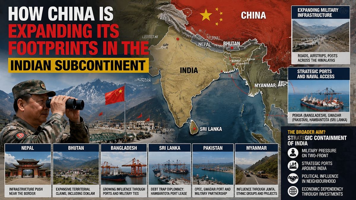
China's Regional Footprint
While China's footprint, or, as some describe it, "creeping expansionism", can be seen across the five fingers, what concerns Indian strategic thinkers is that it has also expanded across the oceans and can now be viewed as an attempt to contain India militarily and economically.
In Nepal, Chinese border encroachments have periodically surfaced in official and unofficial reports, including allegations of infrastructure expansion in districts such as Humla and Sindhupalchowk.
Similarly, Beijing continues to press expansive territorial claims in western, central and eastern Bhutan, including Doklam—a region of direct strategic significance to India because of its proximity to the Siliguri Corridor. In all, China claims more than 1,400 sq km of Bhutan's territory.
China's influence in Dhaka is growing through infrastructure financing, strategic port access and military cooperation, reinforced by the recent visit of Bangladesh's Tarique Rahman to Beijing. The Chinese have shown interest in projects linked to the Mongla Port and the Teesta River basin while expanding involvement in port infrastructure at Chittagong Port and Bangladesh's naval base at Pekua.
The Pekua base is the most intriguing of China's projects, as it can dock eight large destroyers and half a dozen submarines, despite the fact that Bangladesh has no destroyers, only smaller frigates and corvettes, and just two second-hand diesel-powered submarines bought from China. This has led many to suspect that Beijing plans to deploy its own vessels from the port near Cox's Bazar, which can dominate the eastern Bay of Bengal.
The Sri Lankan story of how China leveraged debt to take over Hambantota Port nearly nine years ago through a lease that will run well into the twenty-second century is well known.
Towards the western reaches of the subcontinent, the strategic partnership between China and Pakistan is deeper and more institutionalised. Gwadar Port and the Karakoram Highway form critical components of Beijing's westward connectivity strategy under the China-Pakistan Economic Corridor. The Pakistani Army and Air Force remain aligned with China's, using Beijing's military hardware and spy satellites to maintain their capabilities.
In Myanmar, to the east, China continues to maintain leverage through engagement with both the military junta and multiple armed ethnic groups, ensuring influence regardless of domestic political outcomes. It has also managed to engineer the settlement of a mix of borderland Chinese migrants, infrastructure workers and transnational scam syndicate operators concentrated in northern border regions and special economic zones. Their presence has sharply increased geopolitical and social tensions, particularly amid ongoing armed conflict and human trafficking concerns.
Strategic Challenge For India
Taken together, these developments raise a central strategic question: Is China gradually constructing a geopolitical ring around India? The pattern suggests more than isolated bilateral disputes.
China's simultaneous pressure along India's contested land borders in Ladakh in the west and Arunachal Pradesh in the east, combined with expanding influence in neighbouring states, points to a broader strategy of strategic containment.
This strategy may not resemble classic Cold War encirclement, but it increasingly creates pressure points around India's periphery: contested borders, infrastructure dependencies, strategic ports and political influence in neighbouring capitals.
For India, the challenge is, therefore, no longer purely military; it now extends to geopolitical, economic and demographic contestation. Military readiness remains essential, but India's response must also include stronger regional diplomacy, accelerated border infrastructure and sustained investment in frontier communities. Populated and economically viable border regions are strategic assets. Local communities are often the first to detect shifts on the ground well before satellites, intelligence assessments or diplomatic channels register them.
The contest between India and China is no longer confined to disputed mountain ridges. The rivalry now spans ports, roads, infrastructure corridors and political influence across the subcontinent.
The writer is Editor, United News of India.