Bihar & Uttar Pradesh Shine Brightest In NASA's Latest Nighttime Satellite Map; Netizens Express Pride
NASA’s nighttime satellite map showing global lighting changes between 2014 and 2022 has gone viral after Bihar and parts of Uttar Pradesh appeared among Earth’s brightest regions. Scientists linked the rise to improved electrification and development. Social media users expressed surprise, praising increased electricity access

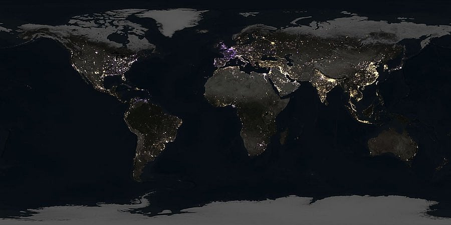
A newly released global nighttime satellite map by NASA has triggered widespread discussion online after northern India, particularly Bihar and parts of Uttar Pradesh, appeared among the brightest illuminated regions on Earth.
The visual, released on April 16, tracks how artificial lighting across the planet changed between 2014 and 2022, offering a striking glimpse into economic growth, electrification, and human activity visible from space.
Northern India’s rapid brightening captured from space
Scientists analysed nearly 1.6 million satellite images collected nightly over nine years to build the global lighting comparison. The data revealed a sharp rise in nighttime brightness across northern India, with the Uttar Pradesh–Bihar belt showing one of the most dramatic increases worldwide.
In the imagery, regions glowing in golden hues represent areas where artificial lighting expanded significantly, while purple tones indicate locations where night-time brightness either stagnated or declined. Large parts of India, China, the Middle East, and Central America appeared brighter over time, whereas much of Europe showed reduced illumination.
What caught public attention most, however, was Bihar’s unexpectedly prominent visibility.
Social media reacts: “Bihar is shining like a diamond”
The map quickly went viral, prompting surprise and pride among social media users.
“Bihar is shining like a diamond,” one user wrote. Another commented, “Wait… Bihar is one of the brightest spots in the world?”
Several users linked the brightness to improved electricity access, rising population density, and expanding infrastructure. One widely shared reaction described the transformation as “one of the most astounding achievements of India in the last decade.”
Others highlighted improvements in power supply, noting that many areas that once received only six to eight hours of electricity now experience near full-day access.
How scientists measured earth’s night lights
The research was led by Tian Li and Zhe Zhu from the University of Connecticut, who used advanced algorithms to analyse data captured by the Visible Infrared Imaging Radiometer Suite (VIIRS).
Mounted on Earth-observing satellites, VIIRS detects light emissions from cities, highways, industries, and settlements, allowing scientists to measure human activity patterns at night. Beyond urban development, the technology helps researchers understand energy consumption, disaster recovery, migration patterns, and economic growth.
Why nighttime satellite data matters
Miguel Roman, deputy director for atmospheres and data systems at NASA Goddard Space Flight Center, emphasised the broader significance of such observations.
“Unlocking energy sector insights is just one way NASA data is advancing national security interests at a critical time,” he said. “Earth at night has so much to teach us.”
Nighttime satellite monitoring is increasingly used worldwide to assess economic recovery, monitor conflict zones, track energy efficiency, and study environmental change.
RECENT STORIES
-
-
-
-
-