Indore News: Drones, Google Maps Deployed To Tackle City Traffic Woes
Indore traffic police have deployed drones and Google Maps’ real-time tracking to curb congestion and enforce no-parking zones. Surveillance in busy areas like Dawa Bazar Road and Regal Square enabled swift action against violators. The colour-coded system helps identify traffic density, allowing quick response, better coordination, and smoother flow across key city intersections.

Eyes in the sky: Drones, Google Maps to declutter city traffic
Our Staff Reporter
Indore
Traffic management police used drone surveillance to enforce no-parking zones and manage congestion during peak hours in the city. The officials said that it is better to see the violators and their location.
On the instructions of DCP (traffic) Rajesh Kumar Tripathi, drones were deployed in busy areas such as White Church, Dawa Bazar Road, Madhumilan Square, RNT Marg, and Regal Square. During monitoring, several vehicles were found occupying two to three lanes in a no-parking zone on Dawa Bazar Road, disrupting traffic.
As soon as the violation was spotted, a patrolling and wheel-lock team arrived and took action. The vehicles were locked, announcements were made to inform drivers, and legal action was taken against the accused.
Police said that due to the quick response, the blocked road was cleared immediately, and traffic resumed smoothly. Officials said such measures will continue to ensure safe and efficient traffic flow in the city.
Real-time tracking for better management
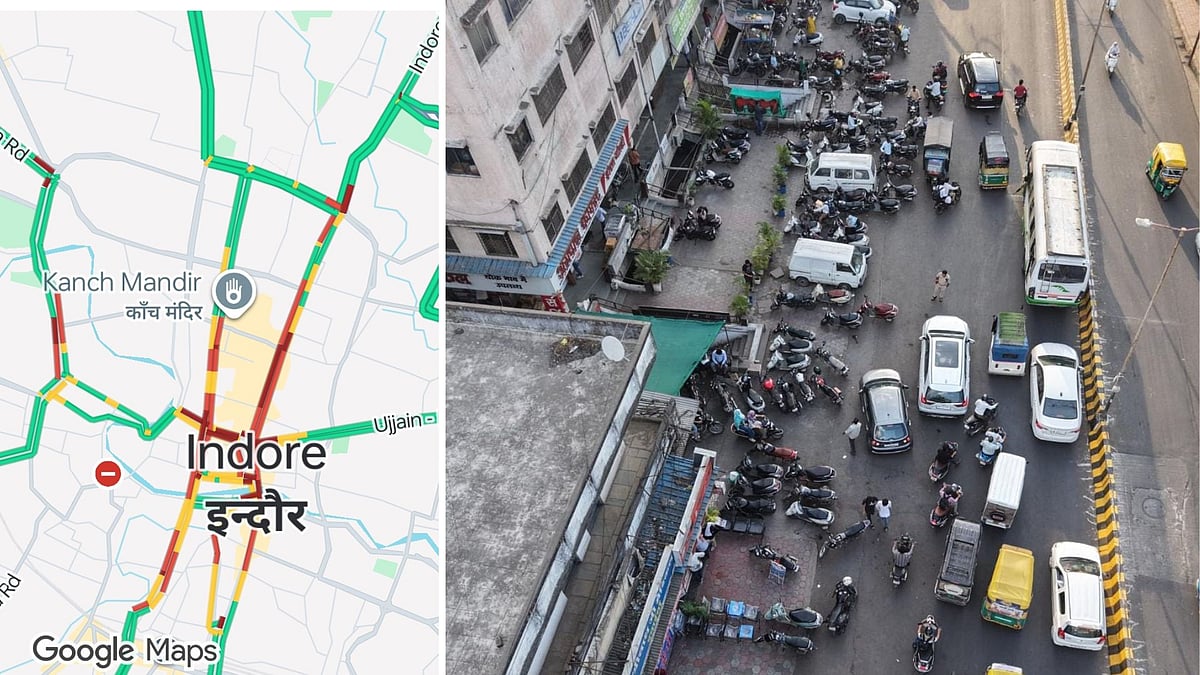
The traffic cops also began using Google Maps' real-time traffic tracking system to improve traffic management in the city. The officials said that this system uses mobile location data and GPS technology to analyse the speed and density of vehicles on roads. It shows traffic conditions using different colours green for smooth traffic, yellow for slow movement, and red for heavy congestion.
With this, traffic police can quickly identify congested areas and dispatch patrol teams to clear traffic. This helps in managing traffic through diversions and manual control when needed. It also ensures smooth movement at major intersections and allows for quick response during emergencies, such as accidents or vehicle breakdowns. Officials said this step will strengthen smart traffic management and improve coordination between the control room and field staff.
Drone Enforcement: Drones deployed to monitor busy areas including White Church, Dawa Bazar Road, and Regal Square to enforce no-parking zones.
Rapid Response: Surveillance identified several vehicles blocking multiple lanes on Dawa Bazar Road, leading to immediate action by patrolling teams who used wheel locks on offending vehicles.
Real-time Tracking: The department has integrated Google Maps’ real-time data to monitor vehicle density and speed across the city.
Visual Management: The system uses a colour-coded interface—green for smooth flow, yellow for slow movement, and red for heavy congestion—allowing the control room to identify bottlenecks instantly.
Smart Coordination: These tech-driven measures aim to improve coordination between the control room and field staff, ensuring quicker responses to accidents, breakdowns, and peak-hour surges.
Published on: Thursday, April 09, 2026, 01:30 AM ISTRECENT STORIES
-
-
-
-
-