Cyclone 'Ditwah' Likely After Storm Senyar; New Deep Depression Forms In Bay Of Bengal, Chennai On Alert
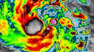
The IMD said that the deep depression over the southwest Bay of Bengal and adjoining Sri Lanka coast was likely to move north northwestwards and strengthen into a cyclonic storm within 12 hours. The department said the weather system would continue to track across the Bay of Bengal and adjoining Sri Lanka toward north Tamil Nadu, Puducherry and south Andhra Pradesh over the next two days.
Cyclone 'Ditwah' Likely After Storm Senyar; New Deep Depression Forms In Bay Of Bengal, Chennai On Alert | X
Chennai: A fresh deep depression over the southwest Bay of Bengal is expected to intensify into Cyclone Ditwah within hours, raising the possibility of impact across Tamil Nadu, Puducherry and parts of south Andhra Pradesh.
The development comes even as Cyclone Senyar, described by meteorologists as a "historic and rare system" in the Strait of Malacca, moves toward Malaysia after forming unusually far east of the Indian coast.
IMD Warns of Intensification and Path Toward Tamil Nadu
The India Meteorological Department said on Thursday, November 27, that the deep depression over the southwest Bay of Bengal and adjoining Sri Lanka coast was likely to move north northwestwards and strengthen into a cyclonic storm within 12 hours.
According to the IMD, the system lay centred at 0530 hours on November 27 near latitude 6.3°N and longitude 82.4°E, around 150 kilometres east of Hambantota in Sri Lanka and 170 kilometres south southeast of Batticaloa.
The department said the weather system would continue to track across the Bay of Bengal and adjoining Sri Lanka toward north Tamil Nadu, Puducherry and south Andhra Pradesh over the next two days. Several districts in Tamil Nadu, including Chennai, Nagapattinam, Thiruvallur and Thanjavur, have been placed under yellow and orange alerts for November 27, 28 and 29. If the system intensifies into a cyclonic storm, it will be named Cyclone Ditwah as per the regional naming roster.
Cyclone Senyar, which developed earlier in the Strait of Malacca, weakened as it moved away from Indian territory. The IMD noted that it lay around 850 kilometres southeast of Car Nicobar and was expected to reduce to a depression.
Cyclone Senyar Called a ‘Historic’ Formation
Meteorologists in Malaysia have highlighted the rarity of Senyar, with MetMalaysia director general Mohd Hisham Mohd Anip saying it was the first time a weather system in the Strait of Malacca had reached cyclonic storm strength. The last system of note in the narrow waterway was a tropical depression in 2017.
According to Malaysian advisories, the system was moving west southwest with sustained winds of 83 kilometres per hour and could deliver heavy rain and strong winds to northern Malaysian states.
Social media users tracking the storm called it one of the rarest events recorded in the region, with some citing United States Joint Typhoon Warning Center forecasts suggesting it could become the first tropical cyclone to make landfall on Malaysia’s western coast.
RECENT STORIES
-
-
-
-
-